Sign up

Get notified via email when we post a new item to the blog.

Sunday, May 21, 2017

Sunset Mallory Square - Day 15


--------------------------------------------------------------


Jack Jenner

Oh lala

Thanks Barry @Chris

Jack and I redeeming​ my retirement gift at Sloppy Joes. Hey Barry... take my job and shove it.   Wait...not until after my last paycheck!


Jack fixes flat

43 miles to go

Jack picked up a nail

6.5 miles across the 7 Mile Bridge, Jack had a flat...Kevlar tires my foot.

Arrival !!! Key West... 90 miles to Cuba

Estoy tan contento de estar fuera de esa maldita bicicleta. Si tuviera un barco, iría a Cuba

Jack's flat on 7 mile bridge

Waking up in Paradise - Morning of the Last Day - Day 15


Day 15 - Sun May 21

Finally, our last day! 50.3 miles (if we cross 7 Mile Bridge today) or 43.3 miles (if we crossed 7 Mile Bridge Yesterday).  Well, we did not cross the 7 mile bridge yesterday. Like George Castanza and Kramer, we stopped short. So, this morning, after we cross the 7 Mile bridge we'll be on Bahia Honda Key. As we continue south, we'll catch the newest part of the bike trail that takes us to Bahia Honda State Park around the 36 mile marker. This is the newest 3 mile stretch of the trail. There are three beaches here. The most popular is what they call Sandspur. It has shallow water sandbars and in the summer, because the water is so shallow, they say it feels like bath water. We will be riding a nice wide shoulder of the road south of Bahia Honda State Park. As we pass the park, we will see the old Bahia Honda Bridge. It was abandoned years ago. It’s an old span bridge the railroad use to use. As we enter Big Pine Key, the shoulder is really wide and the road is enclosed with tall chain link fence. This is to protect the Odocoileus virginianus clavium from walking out into the traffic. As we continue south we'll pass through Little Torch Key.  There are two new trails that will take us off the highway at the 26 mm and the 23 mm. They are not well marked as of yet but when we see a crosswalk on the highway, that will be our clue to turn sharp right into the trail tucked away in the woods. It buys us some peace from highway noise. When the trail ends, we'll need to turn hard right onto the shoulder of the highway again. We'll get to Sugarloaf Key around the 17 mile marker.  Around the 10 mile marker, the bike trail continues on the ocean side. We will be passing the Naval Air Station. We'll probably see jets flying overhead on training missions as we go south.  The path goes down the off ramp by the Air Force base and we can go under the overpass until we get to the 6 mile marker. Around the 6 mile marker, we will land in Stock Island. It’s kind of like the industrial part of Key West. We'll take a sharp left at mile 45.6 and head out on South Roosevelt Blvd. One of my favorite movies of all times is Havana, starring Robert Redford. The critics panned it. I loved it - but I love anything Cuban (Cuban sandwiches, Café con leche, black beans and rice,palomilla steak and flan). The entire film - for the most part - was filmed in the Dominican Republic - not Cuba. The final scene, though,was filmed in Key West, Florida. The final scene where Jack (Robert Redford) looked out over the ocean searching for Bobby (Lena Olin - hard to believe she's Swedish not Cuban) was filmed on this this stretch of Roosevelt Boulevard that we finish our ride on.

Saturday, May 20, 2017

Sunset at Banana Bay Marathon

Check it out - Watch the video

Banana Bay Resort - end of Day 14

7 mile bridge tomorrow as we make our way to our final destination... Mile 0 and the Southern Most marker in Key West. Hard to believe it's almost over. All you old farts out there...you can do it too!

1st Stop Day 14

Bummer...got caught speeding in Layton Key. Will make bail soon and continue the days ride.

Friday, May 19, 2017

Day 14 - Sat May 20

7 Mile Bridge Looking North towards Marathon - We're going South
Sunset last night at Lor-e-Lei was great. Jack is doing great. I have sun-poisoning. Wouldn't you know it - two days to go and I get a disease. Today's ride takes us from Islamorada to Marathon - a distance of  33.4 miles. As we leave the Island of Islamorada, we will pass a little island off to the Oceanside called Terra Key. It’s an island with a large house, tennis courts, dock and an area for a helicopter to land. Gene Hackman use to stay there. Gene Hackman is over 80 and still an avid cyclist. Once, while he was on a bike path here in the Keys, a motorist not paying attention bumped into the rear of his bike causing his rim to look like a taco. He flew from his bike and hit the ground. He got up and brushed it off. Now that's the coach I remember from Hoosiers! At the 72 mile marker we come to our first REAL bridge crossing. It’s Channel 5 Bridge and it’s almost 2 miles. The shoulder is about 5 feet wide. That takes us into Layton. Layton is an interesting little town. It’s actually incorporated, has a mayor, a volunteer fire department and it contracts with the Sheriff’s office to keep an empty patrol car parked out on the highway near it’s flashing light to slow traffic down. When the weeds grow too high, they move the empty patrol car across the street until public works can mow the grass, then back to it’s original location. The locals say that the patrol car should be voted officer of the year. Depending on the weather, the wind , the traffic and our bodies, we will either stop in Marathon or continue across the longest bridge in the Keys - The Iconic 7-mile Bridge. If we decide to cross, the ride today will be a 40.4 mile day. Jack's been across on a motorcycle and I've been across in a car and on foot (7 Mile Bridge Run back in the 80's), but neither of us have crossed it on a bicycle. The bridge is actually 6.8 mile long. Yes, someone from the government lied to us! The shoulder is about 5 feet wide. Arnold Schwarzenegger starred in a film called “True Lies” that was shot partially in the Keys, involving a sequence of helicopter stunts and an explosion on the old Seven Mile Bridge - which is still there and used as a pedestrian/fishing bridge. We plan to stay at Banana Bay Resort & Marina - 4590 Overseas Hwy, Marathon, FL 33050 - (305) 743-3500

Another Sunset View from Islamorada

The view is here...wish you were beautiful.

Sunset at Lor-e-Lei


I caught it

Skippers Dockside at MM100

100 miles to go...replacing electrolytes and consuming Fish Tacos

Downtown Cardsound

Day 13 Alabama Jack's

First stop at 12 miles...strong headwind ... We turn south in about 4 miles so hopefully we'll get some relief going into Key Largo.

Day 13 - Friday May 19

It's raining this morning... yuk Today's ride takes us 50.3 miles from Florida City to Islamorada. US Highway 1 from Florida City to Key Largo is NOT a bike friendly ride. Instead, we will go east out of Florida City on Card Sound Road (CR-905) to the Card Sound Bridge and northern Key Largo. - in the back door so to speak. Card Sound Road traverses a wild area that once had the small community of Card Sound. All that’s left now is Alabama Jack’s, a funky outdoor restaurant and tiki bar known for its conch fritters and the line of motorcycles it attracts.  At mile 25, we will pass by The  Crocodile Lake National Wildlife Refuge - home of the American Crocodile. Crocodiles forage opportunistically eating fish, snakes, crabs, turtles, birds, small mammals and bicyclists. At our mile 33, we will pass the MM (Mile Marker) 100, which means we will have 100 miles until we reach our goal at MM 0. No visit to Islamorada would be complete without an evening at the Lorelei Cabana Bar to watch the sunset. We plan to stay at the Days Inn and Suites- 82749 Overseas Hwy, Islamorada, FL 33036 - (305) 664-3681.

Thursday, May 18, 2017

Arrival Florida City Day 12

Tomorrow we begin our Final Conquest - The Florida Keys!

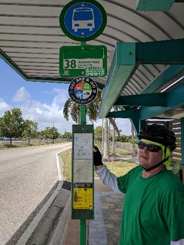
Riding on the Busway

10 miles to go.... Busway is nice.. more bikes than busses...all the way to Florida City...this is Bus stop number 38 at Southland Mall Homestead-Fl City

Beginning of Day 12 at McDonalds

My feet at McDonalds for breakfast. Lazy day on the M-Path and Bus Route.

Wednesday, May 17, 2017

Day 12 - Thur May 18

Today's ride is a relatively short  trip from Coral Gables to Florida City - Homestead - 24.2 miles.  We deserve a break today. Navigating through Miami Traffic was a real nightmare. Our average speed yesterday was 9.4 mph. That's about 5 mph slower than we have been averaging. People here DO NOT know how to drive! We had our first rain shower of the entire trip in Miami around noon. I lost my favorite sunglasses that I've taken on two previous bike trips. But, at the end of the day, we had a great Cuban meal at Havana Harry's. We will finish the M-Path early this morning and pick up the South Dade Trail. The South Dade Trail follows the "Bus Only" road for around 20 miles. We will pass 56 Busway stations on our way south. The areas around the trail range from heavily urbanized to suburban to rural, and are all influenced by the nearby US Highway 1. The M-Path and South Dade Trail have been designated as part of the East Coast Greenway’s system of trails between Key West and Maine. We plan to stay at Holiday Inn Express & Suites Florida City-35200 S Dixie Hwy, Florida City, FL 33034 (305) 247-3414 . Tomorrow - Day 13 - will be our first day in the Keys. It'll be a long day as well - 50 miles to Islamorada. Can't wait!

Cafe con Leche


Una estupenda manera de terminar la comida y el día ... con un café con leche.

Coral Gables

Esta cerveza Presidente es muy bueno. Estamos comiendo cubano de nuevo en Coral Gables.

Jack and Denis

Denis works at the American Airlines Arena

Arrive Home of the Heat

American Airlines Arena

South Beach

1st stop Day 11... South Beach... "Say hello to my little friend..."

Start of Day 11

Props to Sonny at Crowne Plaza for being understanding and kind to two old bikers.

Day 11 - Wed May 17

Today's ride will take us 33.6 miles from Hollywood Beach to Coral Gables . We got lots of great video from Margaritaville last night. Today, we will enjoy three separate but neighboring trails that are part of the East Coast Greenway. First, we pick up the South Beach Trail at  Indian Beach Park (mile14.5). It begins as a boardwalk and will take us all the way through South Beach (think Miami Vice and Scarface). Next we pick up the Miami River Greenway. As of 2014, just over half the Greenway was open to the public—including sections known as the Miami Riverwalk and Baywalk—with many new segments underway. We won't know what to expect until we actually get there but I've read that the views are spectacular. After crossing the MacArthur Causeway to get back mainland, we will pass by the Perez Art Museum, American Airlines Arena (home of the Miami Heat), Miami Marina, Bayside Marketplace and Bayfront Park Amphitheatre. Then we cross the Miami River via Brickell Avenue Bridge and at mile 26.4, we'll join up with the famous M-Path trail. The M-Path is a paved multi-use trail in urban Miami-Dade County, which was opened in 1983 and is part of the Miami-Dade Transit (MDT) system.  It runs close to 10 miles and helps cyclists avoid the extreme traffic going through Miami. Plans are underway to re-develop the M-Path. It will be re-named the Underline - a $120M Underline master plan for linear park that will be completed by 2022. The M-Path links up with the South Dade Trail (Bus Trail) which we will start out on tomorrow. Combined, the 30-mile long M-Path and South Dade Trail (Bus Trail) make up a nearly continuous paved path from downtown Miami to Florida City along the Metro-rail elevated rail line and the South Miami-Dade Busway transit facilities. We plan to stay at the Holiday Inn Coral Gables - University of Miami - 1350 S Dixie Hwy, Coral Gables, FL 33146 - (305) 667-5611

Tuesday, May 16, 2017

Fish Tacos and Cheeseburger

I hate it when people put pictures of their food on the internet. WHO CARES!

Cheeseburger in Paradise

This place is awesome!

Jack did it.... Finally!

Lost in Margaritaville

Wave Pool Hollywood

The wave pool at Jimmy Buffet s in Hollywood FL. Jack is getting fitted for a board .

Ft Lauderdale

I feel so small and insignificant

First Stop Day 10

Ft Lauderdale Beach....Last time I was here was Spring Break 1971. We are over half way to Hollywood - our stop for tonight.

Day 10 - Tue May 16

We Are the People Our Parents Warned Us About
Today's ride takes us from Highland Beach (S. Delray Beach) to Hollywood Beach. 32.1 miles. We will have some of the most scenic riding of the trip today as well as some of the most treacherous. We will get to enjoy wide ocean-side boardwalks in Ft. Lauderdale and later in Hollywood Beach. In between though, we will have to go inland through a heavily industrialized area in order to avoid the huge limited access area that makes up Port Everglades. Not only is Port Everglades the third busiest cruise port in the world, it is the busiest container port in Florida and 10th busiest in the United States. We plan to stay in Hollywood Beach at the Crowne Plaza 4000 South Ocean Drive - 954-454-4334. We'll be about 3 miles from Jimmy Buffett's Margaritaville Hollywood Beach Resort which opened in 2015. Nightly rates at Margaritaville start at $259 per night. We'll probably go there via Uber or Lyft.

Monday, May 15, 2017

End of Day 9 Highland Beach FL

Staying and eating at the Delray Sands Ocean Front. Turtles are nesting, so I'll try to get some pictures around dusk. We are over 1/2 way to our goal.... 6 days left.

Worth Avenue

At the end of Worth Avenue...1 mile from Donald's Place. Lots of funny named clothing stores on Worth Avenue

Mermaid under the Bridge

2 miles to Trump's place. Plan to eat with the Donald.

Blue Heron Bridge

Over Intracoastal with Peanut Island in background

Singer Island at Peanut Island

Lisa is riding to Mar-a-Lago with us and then going back to Juno. We will continue on a other 18 miles after that to Delray Beach.

Singer Island

Jus off Peanut Island

Sunday, May 14, 2017

Day 9 - Mon May 15

Today's ride takes us from Juno Beach to Highland Beach, a distance of 36.5 miles. We will need to shave and  dress in our best bike shorts today because we will be passing through some of the most highfalutin neighborhoods of the entire trip - West Palm Beach. West Palm Beach is west of Palm Beach, south of Palm Beach Gardens and North Palm Beach, southwest of Palm Beach Shores, and east of Royal Palm Beach. This group of cities and the vicinity is known as—wait for it—“the Palm Beaches.” They are located in Palm Beach County. It’s a beach to keep straight. Heck, we'll even drive right by our Southern White House today - The Mar-a-Lago Club at mile 18.2. After lunch with the President, we'll go another 18 miles south where poor people (relatively speaking of course) live and we can afford a place to stay.  We will stay at the Delray Sands Resort - 2809 S Ocean Blvd, Highland Beach, FL 33487 - (561) 278-6241  

Lisa loves Cafe con Leche!

Havana's for Cafe con Leche

Late nite nitecap in Lake Worth

Jack eats Sushi

WaaaaaaaaasaAAABEEEEE

Night Out in Jupiter Fl

Jack and Lisa from Pedego ... Dinner at uTikis

End of Day 8 - Juno Beach Pedego


Jack was interviewed by WPBF ABC affiliate. Stay tuned ... film at 11. Tomorrow, we invade Mar-a-Lago (Trumpland)!